Stop and Stair

Hike the Communications Hill Grand Staircase to Views of San Jose
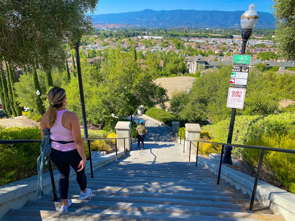
Settled in 1777, Communications Hill is one of the oldest neighborhoods in California, yet its Grand Staircase is a modern delight for urban hikers. This 252-step staircase and 2-mile (round-trip) trail offer beautiful views of Silicon Valley without ever leaving San Jose.

Grand Staircase in Communications Hill

Hiker taking in the panoramic view of San Jose at the top of Communications Hill Grand Staircase

Hikers begin their journey at the corner of Mullinix Way and Montevarchi Street. While climbing the white stone staircase, be sure to stop and take a look over your shoulder, as the surrounding peaks will soon be visible over the city skyline. At Communications Hill Trail, cross the trail to continue up the staircase.

This final stretch is lined with stately columnar trees and classic lampposts, making this a popular spot for photos, especially at sunset. Once atop the stairs, a beautiful vista awaits: San Jose, with a backdrop of the Santa Cruz Mountains, including Loma Prieta and Mount Umunhum.

At the top of the staircase, turn left to follow Casselino Drive, its stone balconies the perfect spots to stop and soak up the view. Then turn right onto Empoli Street for a glimpse of the decommissioned microwave tower that marks the top of Communications Hill.

Retrace your steps back to the Grand Staircase, and descend to Communications Hill Trail, which stretches between Casselino Drive and Vieira Park. This flat, paved stretch is perfect for strollers and dogs, and is ADA accessible. Vieira Park, named for the neighborhood’s early inhabitants, is a great place to refill water bottles, enjoy a picnic lunch, or let the kids blow off some steam on the small playground.

When you’ve had your fill of fun, return to the staircase and retrace your steps back down to Mullinix Way.

The bottom of the staircase can be found at the intersection of Mullinix Way and Montevarchi Street. From CA-87, exit onto E Capitol Expwy. Turn right onto Pearl Ave., then Hillsdale Ave. Turn left onto Regency Ave., then right onto Marble Arch Ave. At the intersection of Montevarchi and Mullinix, the staircase will be on the left. Street parking is available. The staircase is open to the public, but closed at night. Dog-friendly!

Story and photos by Heather Werner, @heath.er.wer.ner

Trending Stories NorCal

View all Stories
  1. Taking the Stage: Tyler Ranch

    Hike the recently opened Tyler Ranch Staging Area in Pleasanton Ridge Regional Park, with 18 miles of new trails. This 6.5-mile loop up Sunol Peak is a challenge and rewards with exceptional views of seasonal iridescent hills.

    View
  2. A woman stands at Dante's View in Death Valley, looking out to Telescope Peak and Manly Lake, Badwater Basin below.

    Sunset Hike (and Manly Lake Vista!) at Dante's View

    It’s one of the world’s best places to watch a sunset. Dante’s View is a 5,476-foot vantage of the whole southern basin of Death Valley from the top of the Black Mountains. On clear days you get views of both the highest and lowest points in the contiguous U.S. 

    View
  3. Swing into Spring

    Swing into this 7.1-mile hike in the hills of Half Moon Bay! It’s got gorgeous views, fields of spring wildflowers, and a hidden rustic tree swing.

    View
  4. The Carson Show

    Carson Falls is ready for primetime. This three-tiered, 100-foot stunner is hidden back in a canyon outside of Fairfax and reached on a 3.25-mile (round-trip) hike.

    View

Trending Stories SoCal

View all Stories
  1. Lava Lava

    Once a land of volcanic activity, Mojave National Preserve shares plenty about its past via a quick yet adventurous hike to the Lava Tube in the Cima Dome Volcanic Field.

    View
  2. Kelso Dunes

    The hike to the top of Kelso Dunes in the Mojave National Preserve is only 3 miles (out and back), but you’ll feel like you’ve hiked much farther by the time you’re done.

    View
  3. William Kenyon Overlook

    Some of the best vistas of Anza-Borrego Desert State Park are easily accessible via a short and sweet 1.25-mile (round-trip) hike just off the CA-78. Enter your next favorite desert viewpoint: the William Kenyon Overlook.

    View
  4. Beaudry Bountiful

    There are no cars allowed on Beaudry Loop, but this 6-mile hike takes you on a wild ride. You’ll be climbing 1,500 feet up the southern Verdugos along a chaparral-lined trail with gorgeous mountain and urban vistas every step of the way.

    View