Hike the Thomas Creek Trail in Reno's Galena Creek Regional Park

Go Galena

Hike the Thomas Creek Trail in Reno's Galena Creek Regional Park

hikers on the Thomas Creek Trail in Mount Rose Wilderness near Reno

Just 20 minutes from Reno, Galena Creek Regional Park is unassuming amid dense forest on the eastern slope of the Sierra Nevada. But wow has it got wilderness! Mount Rose Wilderness, to be specific.

hiker on the Thomas Creek Trail near Reno

hikers on the Thomas Creek Trail in Mount Rose Wilderness Reno

hikers on the Thomas Creek Trail in Mount Rose Wilderness Reno

You'll need an early start for this beautiful 15-mile out-and-back journey to heights with huge views of the Washoe Valley and surrounding mountains. The hike starts at Upper Thomas Creek and enters Mount Rose Wilderness (see italics for an alternate parking option to make this an 11-mile out-and-back). Forest bathe most of the way under a mix of mountainous Jeffrey pine, ponderosa, and white fir.

hiking woman on Thomas Creek Trail in Galena Creek Park

Find more great hikes around Reno!

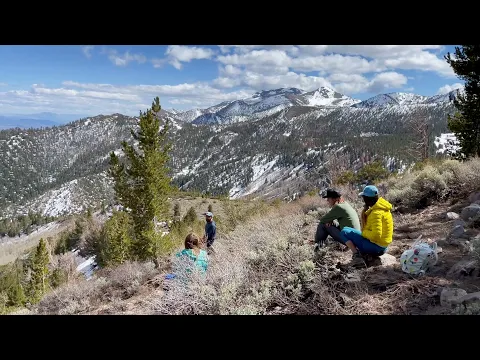
You’re often alongside the creek, favored by anglers soaking in the quiet oasis. Creek crossings as of late are totally manageable, and the ascent is gradual and gentle. The last 3 miles are where you get mountain magic, as you leave the forest and begin gradual switchbacks in the basin of snow-tipped mountains and up to a ridge where you may have to tramp through patches of snow. The ridge is your turnaround point, but not before you turn around—and around—to take in the view.

hikers on Thomas Creek Trail in Galena Creek Park

hikers looking at wilderness information sign Mount Rose Wilderness Reno

hikers near Reno on Thomas Creek Trail

From here you have a wide and vast vista of Washoe Valley, with the Junction House Range in the foreground and the Hungry Range in the distance. To the west lies Chocolate Mountain, a less-known peak to consider bagging in summer.

TIP: Galena Creek Regional Park is also popular with mountain bikers.

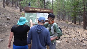
Pay close attention to trail signs at Galena Creek Regional Park—there are sections in the first several miles where you briefly come out to a fire road before rejoining the trail in a few hundred feet. To shorten the length of this hike, take Thomas Creek Road up to a parking area with just a handful of spots in the forest at a bridge crossing. Either way, bring plenty of water and snacks and get an early start. This adventure is best for spring and summer days when there’s more daylight. Check out other great Reno hikes! This is an out-and-back trail. Dog-friendly!

Trending Stories NorCal

View all Stories
  1. Taking the Stage: Tyler Ranch

    Hike the recently opened Tyler Ranch Staging Area in Pleasanton Ridge Regional Park, with 18 miles of new trails. This 6.5-mile loop up Sunol Peak is a challenge and rewards with exceptional views of seasonal iridescent hills.

    View
  2. A woman stands at Dante's View in Death Valley, looking out to Telescope Peak and Manly Lake, Badwater Basin below.

    Sunset Hike (and Manly Lake Vista!) at Dante's View

    It’s one of the world’s best places to watch a sunset. Dante’s View is a 5,476-foot vantage of the whole southern basin of Death Valley from the top of the Black Mountains. On clear days you get views of both the highest and lowest points in the contiguous U.S. 

    View
  3. Swing into Spring

    Swing into this 7.1-mile hike in the hills of Half Moon Bay! It’s got gorgeous views, fields of spring wildflowers, and a hidden rustic tree swing.

    View
  4. The Carson Show

    Carson Falls is ready for primetime. This three-tiered, 100-foot stunner is hidden back in a canyon outside of Fairfax and reached on a 3.25-mile (round-trip) hike.

    View

Trending Stories SoCal

View all Stories
  1. Lava Lava

    Once a land of volcanic activity, Mojave National Preserve shares plenty about its past via a quick yet adventurous hike to the Lava Tube in the Cima Dome Volcanic Field.

    View
  2. Kelso Dunes

    The hike to the top of Kelso Dunes in the Mojave National Preserve is only 3 miles (out and back), but you’ll feel like you’ve hiked much farther by the time you’re done.

    View
  3. William Kenyon Overlook

    Some of the best vistas of Anza-Borrego Desert State Park are easily accessible via a short and sweet 1.25-mile (round-trip) hike just off the CA-78. Enter your next favorite desert viewpoint: the William Kenyon Overlook.

    View
  4. Beaudry Bountiful

    There are no cars allowed on Beaudry Loop, but this 6-mile hike takes you on a wild ride. You’ll be climbing 1,500 feet up the southern Verdugos along a chaparral-lined trail with gorgeous mountain and urban vistas every step of the way.

    View