Easiest Best Hike in the World

Hike to Yosemite's Sentinel Dome and Taft Point

Taft Point Yosemite

Choose the easiest and most view-rewarding hike in Yosemite. Okay, we’ll go first: the combination of hiking to Sentinel Dome and Taft Point. Both of these lookouts are within a couple miles of each other on Glacier Point Road, and they’re connected by a nice walking trail surprisingly few people use.

All in, this 4.5-mile (round-trip) route is referred to by locals as “the easiest best hike in the world.” Sure, it is pretty easy. But with the elevation you’re at and a few moderate ups and downs, you can still feel a little out of breath, so take your time! The reward is some of the most spectacular views of the park.

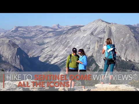
Start this hike by heading to Sentinel Dome first—a nice 1.1-mile hike. The final bit on the actual dome is fun, and not sketchy. You’ll plateau on top with views spanning El Cap, Yosemite Falls, Half Dome, and the saw-toothed ruggedness of the High Sierra. (This view rivals the one at Clouds Rest—and is a fraction of the distance.)

Hike Sentinel Dome Taft Point Yosemite

After Sentinel Dome, continue to Taft Point. There are a couple of ways to get there, and we recommend the longer route (2.5 miles) that runs along the rim of the valley. There are surprisingly fewer people on this section, so you may have it to yourself. There’s also a very short detour to Roosevelt Point. Taft Point is simply stunning.

Hike Sentinel Dome Taft Point Yosemite

You’ll get an IMAX view of El Capitan and all down through the valley. Time your hike to be at Taft Point for sunset, and you’re in for a very special experience.

Drive on Glacier Point Rd. for 13.4 miles and park at the Taft Point and Sentinel Dome Trailhead. Be sure to bring a flashlight if you stay for sunset. We highly recommend you don’t wait until dark before hiking the 1 mile out … hike out while you still have light left. NOTE: It seems so obvious that it shouldn’t have to be mentioned, but Taft Point is not the place to be doing handstands and scissor-kick photos at its famous edges—that selfie is not worth it if stuff goes wrong … and it can go very wrong! Enjoy the setting, be smart. No dogs.

Trending Stories NorCal

View all Stories
  1. Taking the Stage: Tyler Ranch

    Hike the recently opened Tyler Ranch Staging Area in Pleasanton Ridge Regional Park, with 18 miles of new trails. This 6.5-mile loop up Sunol Peak is a challenge and rewards with exceptional views of seasonal iridescent hills.

    View
  2. A woman stands at Dante's View in Death Valley, looking out to Telescope Peak and Manly Lake, Badwater Basin below.

    Sunset Hike (and Manly Lake Vista!) at Dante's View

    It’s one of the world’s best places to watch a sunset. Dante’s View is a 5,476-foot vantage of the whole southern basin of Death Valley from the top of the Black Mountains. On clear days you get views of both the highest and lowest points in the contiguous U.S. 

    View
  3. Swing into Spring

    Swing into this 7.1-mile hike in the hills of Half Moon Bay! It’s got gorgeous views, fields of spring wildflowers, and a hidden rustic tree swing.

    View
  4. The Carson Show

    Carson Falls is ready for primetime. This three-tiered, 100-foot stunner is hidden back in a canyon outside of Fairfax and reached on a 3.25-mile (round-trip) hike.

    View

Trending Stories SoCal

View all Stories
  1. Lava Lava

    Once a land of volcanic activity, Mojave National Preserve shares plenty about its past via a quick yet adventurous hike to the Lava Tube in the Cima Dome Volcanic Field.

    View
  2. Kelso Dunes

    The hike to the top of Kelso Dunes in the Mojave National Preserve is only 3 miles (out and back), but you’ll feel like you’ve hiked much farther by the time you’re done.

    View
  3. William Kenyon Overlook

    Some of the best vistas of Anza-Borrego Desert State Park are easily accessible via a short and sweet 1.25-mile (round-trip) hike just off the CA-78. Enter your next favorite desert viewpoint: the William Kenyon Overlook.

    View
  4. Beaudry Bountiful

    There are no cars allowed on Beaudry Loop, but this 6-mile hike takes you on a wild ride. You’ll be climbing 1,500 feet up the southern Verdugos along a chaparral-lined trail with gorgeous mountain and urban vistas every step of the way.

    View