What a Rush!

Hiking to Cataract Falls on Mount Tam

Mount Tam’s Cataract Falls is the bobsled course of waterfalls: over a mile of twisting, turning, tumbling water—gushing, rushing, and making a splash! The real joy is hiking right beside Cataract Creek as it’s chugging on all cylinders, where the exclamations are 20- and 30-foot falls.

One of the best ways to get there is by beginning from the top of the falls and hiking to the bottom, then returning the way you came. Starting from West Ridgecrest Road, hike down to the Laurel Dell picnic area, an oasis in its own right, shrouded in redwoods and green ferns. Here you’ll pick up Cataract Trail, much of it a series of wooden and rock steps.

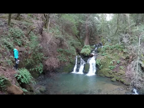
The sound of water is a constant companion even if you don’t yet see the falls—the first of which is reached within a quarter mile. Keep going down, stopping to observe the deep grottoes created by the multi-flowing tiers. A wooden bridge crossing over Cataract makes a good turnaround point; in the distance you can spy Alpine Lake, its bright blue hue tempting you to carry onward for a longer out-and-back hike.

BONUS SUNSET: Time your waterfall hike to finish just before sunset and cross the road from the parking area, where you walk for a few minutes out to hilltops and outcroppings with sweeping views of the headlands, Stinson Beach, Bolinas, Point Reyes, and all the way out to the Farallon Islands.

To get there, drive on Panoramic Hwy. toward Pantoll Campground in Mount Tamalpais State Park. Turn right onto Pantoll Rd. toward Rock Springs just before Pantoll Campground. At Rock Springs drive 1.4 miles on West Ridgecrest Blvd. and park at a pullout on the right. Here's a map (you'll see a sign for Marin Municipal Water District). Walk down the fire road; at the bottom turn right on Ray Murphy Trail, cross the bridge, and turn left on Cataract Trail. Follow this 1.5 miles down. Return the way you came. Because this hike is in Marin Municipal Water District land, it's dog-friendly!

Trending Stories NorCal

View all Stories
  1. Paint Brushy

    This time of year you’ll have good reason to head for the hills—the electric-green rolling hills of Brushy Peak Regional Preserve in Livermore. This 4.5-mile loop hike is like stepping into a plein air painting.

    View
  2. Woman hiker is climbing up the ladder in the Steep Ravine section of the Dipsea Loop Trail on Mount Tam

    Misty on Mount Tam

    Mount Tam’s 3.9-mile round-trip Steep Ravine and Dipsea Trail Loop weathers the wets and wilds with some confidence, sheltered in parts by redwoods, and wowing with a waterfall.

    View
  3. All right, Almaden!

    Take a trip through time on this 5-mile loop in Almaden Quicksilver County Park. Explore the ruins of an old cinnabar mine and enjoy the first hints of wildflower season.

    View
  4. Up and Umunhum

    Early risers can experience one of the Bay Area’s best morning glory hikes on this 7.4-mile out-and-back up beautiful Mount Umunhum. In early spring if you arrive at the parking area right before sunrise, you’ll get a beautiful eastern view of the sun coming up between Bald Mountain and the nearby Santa Cruz Mountains. On days when fog settles into the valley, the colorful view is nothing short of magical.

    View

Trending Stories SoCal

View all Stories
  1. Sponsored

    Weekend in Reno Tahoe

    Weekend plans? Reno Tahoe! Just a few hours by car or a short flight away, Reno Tahoe springs to the moment with great ways to combine adventure and relaxation in its beautiful mountains-meets-desert setting.

    View
  2. Hiker walking along the North Bluff Trail on Santa Cruz Island, Channel Islands National Park

    Purely Wild

    Channel Islands National Park lives up to its nickname as “North America’s Galapagos.” This less-traveled national park is an undeveloped and isolated series of five dramatic and distinct islands reached by boat. Hike the largest of the islands, Santa Cruz.

    View
  3. Woman hiking the South Kaibab Trail in the Grand Canyon

    Truly Grand Day Hike

    One of the best spring day hikes in the Grand Canyon? See layer upon layer of the park’s grandeur—including the river—on this 3-mile (one-way) journey to Skeleton Point via the South Kaibab Trail.

    View
  4. A woman stands amid an array of yellow and purple flowers at Descanso Gardens in Los Angeles

    Petal Paradise

    Tulips, lilacs, and daffodils—flower power is in full bloom at Descanso Gardens in La Cañada Flintridge. Sprawling across 150 acres surrounded by mountains, the gardens are putting on their best show right now.

    View