Getty Up

Get Great Views on a hike at Getty View Park in Los Angeles County
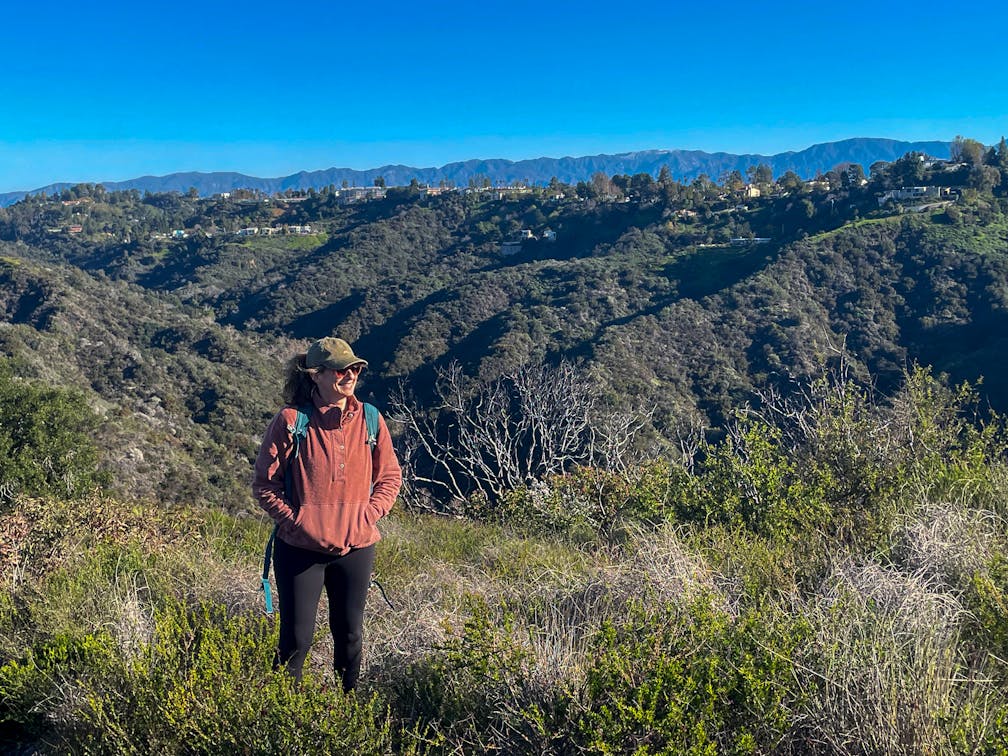
Leave the congestion of the 405 behind on this 3-mile hike at Getty View Park. It’s an oasis high above the freeway that delivers wide-open views of Los Angeles and the iconic Getty Center.

From the trailhead, head north on East Sepulveda Fire Road and follow an easygoing path along the ridge. You’ll have a bird’s-eye view of the busy freeway below, and perched atop the Santa Monica Mountains across the way, you’ll see the Getty’s curvy modern architecture, with its brilliant travertine stone facade and its tram ascending the hill. 

The fire road continues, highlighting the canyons surrounding Bel Air, until you reach a gate. For a simple out-and-back, return the way you came. Better yet, make a left and follow the path that takes you up the hilltops surrounding the fire road. (The path will sometimes drop you back onto the fire road, so be sure to keep rejoining it on the leftward side). 

This route has you tackling some climbs and steep descents, but it’s well worth the effort.  On a clear day, you’ll have sweeping views of the city from the San Gabriel Mountains to the Pacific. From this spacious expanse of urban-meets-natural beauty, your commute feels left in the dust. For the moment.

To get to Getty View Park, take the 405 N and exit at 57B for Moraga Dr. Turn left on Bellagio Rd. and follow it until it turns into Casiano Rd. Stay on Casiano until you reach the trailhead at the end of the road. There is free street parking on Casiano Rd. Dog-friendly!

Story and photos by Yvonne Pasquini, @yvonne_pasquini


Trending Stories NorCal

View all Stories
  1. Taking the Stage: Tyler Ranch

    Hike the recently opened Tyler Ranch Staging Area in Pleasanton Ridge Regional Park, with 18 miles of new trails. This 6.5-mile loop up Sunol Peak is a challenge and rewards with exceptional views of seasonal iridescent hills.

    View
  2. A woman stands at Dante's View in Death Valley, looking out to Telescope Peak and Manly Lake, Badwater Basin below.

    Sunset Hike (and Manly Lake Vista!) at Dante's View

    It’s one of the world’s best places to watch a sunset. Dante’s View is a 5,476-foot vantage of the whole southern basin of Death Valley from the top of the Black Mountains. On clear days you get views of both the highest and lowest points in the contiguous U.S. 

    View
  3. Swing into Spring

    Swing into this 7.1-mile hike in the hills of Half Moon Bay! It’s got gorgeous views, fields of spring wildflowers, and a hidden rustic tree swing.

    View
  4. The Carson Show

    Carson Falls is ready for primetime. This three-tiered, 100-foot stunner is hidden back in a canyon outside of Fairfax and reached on a 3.25-mile (round-trip) hike.

    View

Trending Stories SoCal

View all Stories
  1. Lava Lava

    Once a land of volcanic activity, Mojave National Preserve shares plenty about its past via a quick yet adventurous hike to the Lava Tube in the Cima Dome Volcanic Field.

    View
  2. Kelso Dunes

    The hike to the top of Kelso Dunes in the Mojave National Preserve is only 3 miles (out and back), but you’ll feel like you’ve hiked much farther by the time you’re done.

    View
  3. William Kenyon Overlook

    Some of the best vistas of Anza-Borrego Desert State Park are easily accessible via a short and sweet 1.25-mile (round-trip) hike just off the CA-78. Enter your next favorite desert viewpoint: the William Kenyon Overlook.

    View
  4. Beaudry Bountiful

    There are no cars allowed on Beaudry Loop, but this 6-mile hike takes you on a wild ride. You’ll be climbing 1,500 feet up the southern Verdugos along a chaparral-lined trail with gorgeous mountain and urban vistas every step of the way.

    View