Holy Wow!

Hike Mount McCoy in Simi Valley
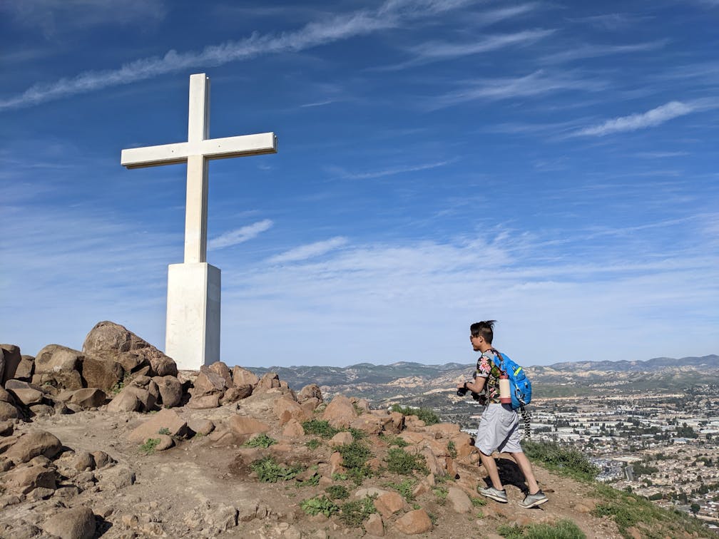
Ready for a heavenly hike? Simi Valley’s Mount McCoy, managed by the Rancho Simi Recreation and Parks District (with help from the Rancho Simi Trailblazers), is a 2.5-mile (out-and-back) suburban rambler that climbs 525 feet in 1.25 miles and features non-stop panoramic views, beautiful native flora, and a giant white cross at the hill’s summit.

Hiker on a trail flanked by cacti at Mount McCoy in Simi Valley

Hiker on a trail leading up to a giant cross at Mount McCoy in Simi Valley

Hiker sitting at a bench on Mount McCoy near a giant cross overlooking Simi Valley

Park at the corner of Washburn Street and Los Amigos Avenue in the quiet suburbs of West Simi Valley. After going through the gate, head south along the dirt trail, past dense groves of prickly pear cactus, with miraculous pink and orange blooms in spring. There are a couple of spur trails, but stay south for a quarter mile before the route turns sharply north and begins a series of rigorous switchbacks enhanced by growing views to the east of Simi Valley framed by the Santa Susana Mountains. 

Hiker on a trail at Mount McCoy in Simi Valley

There are spur trails throughout that go straight up, but stick to the switchbacks to avoid the steep, slippery sections and to be respectful of the primary trail. Enjoy chaparral and coastal sage scrub classics including surprise oaks and rosemary. Look to the south for Sinaloa Lake, a peaceful 12-acre reservoir. As you reach a plateau, you’ll be greeted by some benches and more incredible views to the south and west, including the giant Bard Lake, a 231-acre reservoir that is the largest in the area. You can also spy the Ronald Reagan Presidential Library to the west, perched upon a hill.

Giant cross at the top of Mount McCoy in Simi Valley

Take the last gradual approach north to the cross itself, a 12-foot concrete behemoth erected in 1941 by the Simi Valley-Moorpark Lions Club. You don’t have to be religious to appreciate the divine views at the 1325-foot summit of Mount McCoy. Enjoy them with a picnic among the rocks before heading back down the way you came, taking in the continuous views on your way back to the original trailhead and your car.

Hiker taking in the wide open mountain and valley scenery from Mount McCoy in Simi Valley Ventura County

To get to the Simi Cross trailhead, take the CA-118 to the Madera St. exit and head south. After 1.5 miles, turn right onto Royal Ave., followed by a quick right onto Acapulco Ave. and a quick left onto Washburn St. After 0.2 mile you reach the intersection with Los Amigos Ave. and the trailhead. Dog-friendly!

Story and photos by Matt Pawlik, @mattitudehikes

Trending Stories NorCal

View all Stories
  1. Bear Hug

    This 5.5-mile loop through Coyote Lake-Harvey Bear Ranch County Park explores one of the newest segments of the acclaimed Bay Area Ridge Trail, one redolent with trees ranging from madrone and manzanita to buckeye and blue elderberry (with a bubbly post-hike bonus).

    View
  2. Field of Light at Sensorio in Paso Robles

    Light This Way

    Hidden in the bucolic hills of Paso Robles lies one of the greatest light shows on earth. The lighted art exhibition, Sensorio, is as if the rainbow magic of the aurora borealis was plucked from the sky and planted in the fields.

    View
  3. Bikers and walkers on the Bay Area Ridge Trail with the Golden Gate Bridge behind them

    National Park City Walk

    See San Francisco the way locals do by hiking the Presidio, a national park right in the city! Wooded trails, secluded beaches, and epic views of the Golden Gate Bridge feature on this 5.5-mile out-and-back on the Bay Area Ridge Trail. It’s a lovely slice of the City by the Bay.

    View
  4. Hike top Angel Island Mount Livermore San Francisco Bay

    Good Heavens

    The 4-mile hike to the top of Angel Island offers Bay-mazing scenery. Some people claim you get a five-bridge view: Richmond-San Rafael, Bay, Golden Gate, San Mateo-Hayward, and Dumbarton bridges.

    View

Trending Stories SoCal

View all Stories
  1. Sponsored

    Tram to Cool Treks

    Elevate your fun, getting whisked from palm trees to alpine wilderness on the world’s largest rotating tramcar. The Palm Springs Aerial Tramway transports you up and away on a 2.5-mile scenic route from the desert floor to the refreshing wilderness of Mount San Jacinto State Park.

    View
  2. Coming Up Roses

    Looking to spice up your hiking life? Give your partner a rose—Mount Rose! The 10-mile out-and-back peak hike goes up to one of the grandest views in all of Lake Tahoe. Get ready f

    View
  3. A group of people clamored around the summit marker at Mission Peak in the Bay Area

    Your Mission Is Less Crowded

    Mission Peak is one of the Bay Area’s most popular mountains, with many hikers climbing every weekend. Skip the crowds with this 6-mile loop up the less-traveled southern route.

    View
  4. Bucks Up!

    Come on in, the water is beautiful. Whether you like swimming, kayaking, stand-up paddling, or heading out on a bigger boat, Bucks Lake is a high mountain haven that’s easy to access, blissfully uncrowded, and surrounded by sandy beaches, picnic areas, pines, and aspens.

    View