Hike San Francisco's Crosstown Trail

Cross It Off Your Bucket List

Hike the Crosstown Trail in San Francisco

Crosstown Trail San Francisco may be one of the most beautiful city walks in America. It passes through many of the less-visited nooks and crannies while also taking in the greatest hits. Cutting diagonally across San Francisco from Candlestick Point in the southeast up to Lands End in the northwest, the entire journey is just under 17 miles, with a variety of terrain from sidewalks to stairways and dirt trails. 

And the views? Well, there are multiple spots where the word “sweeping” comes to mind—like Grandview Park. If you don’t want to knock it all out in one day, we recommend this 7-mile hike from Glen Park BART to the Rose Garden in Golden Gate Park. It combines Sections 2 through 4 as defined on the official Crosstown Trail site (you’ll definitely want to download a map, directions, and even the app to stay on the route). 

This section is generally lightly trafficked. Grab a coffee in Glen Park, then start walking to its namesake park, winding up through it, joining some residential streets, and continuing through the trails at Laguna Honda. The quiet streets of the Forest Hill neighborhood are perfect for walking.

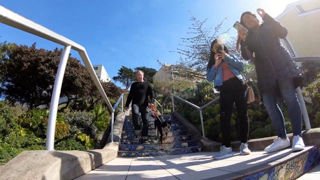
From here you make your way north, taking in Grandview Park and San Francisco’s most Instagrammed staircase—the 16th Avenue Tiled Steps (okay, so you will see tourists here, lots of them). Tip: The equally beautiful Hidden Garden Tiled Steps are just a couple of blocks away and not nearly as busy. The homestretch takes you through Golden Gate Park. Watch the paddleboats and ducks at Stow Lake for a little meditative time. When you reach the Rose Garden, you’ll have wandered about 7 miles—well done! 

The Crosstown Trail website has great information on this hike. You can take MUNI to various parts of the trail: Here’s transit info for the Crosstown Trail. Dog-friendly!

Trending Stories NorCal

View all Stories
  1. Taking the Stage: Tyler Ranch

    Hike the recently opened Tyler Ranch Staging Area in Pleasanton Ridge Regional Park, with 18 miles of new trails. This 6.5-mile loop up Sunol Peak is a challenge and rewards with exceptional views of seasonal iridescent hills.

    View
  2. A woman stands at Dante's View in Death Valley, looking out to Telescope Peak and Manly Lake, Badwater Basin below.

    Sunset Hike (and Manly Lake Vista!) at Dante's View

    It’s one of the world’s best places to watch a sunset. Dante’s View is a 5,476-foot vantage of the whole southern basin of Death Valley from the top of the Black Mountains. On clear days you get views of both the highest and lowest points in the contiguous U.S. 

    View
  3. Swing into Spring

    Swing into this 7.1-mile hike in the hills of Half Moon Bay! It’s got gorgeous views, fields of spring wildflowers, and a hidden rustic tree swing.

    View
  4. The Carson Show

    Carson Falls is ready for primetime. This three-tiered, 100-foot stunner is hidden back in a canyon outside of Fairfax and reached on a 3.25-mile (round-trip) hike.

    View

Trending Stories SoCal

View all Stories
  1. Lava Lava

    Once a land of volcanic activity, Mojave National Preserve shares plenty about its past via a quick yet adventurous hike to the Lava Tube in the Cima Dome Volcanic Field.

    View
  2. Kelso Dunes

    The hike to the top of Kelso Dunes in the Mojave National Preserve is only 3 miles (out and back), but you’ll feel like you’ve hiked much farther by the time you’re done.

    View
  3. William Kenyon Overlook

    Some of the best vistas of Anza-Borrego Desert State Park are easily accessible via a short and sweet 1.25-mile (round-trip) hike just off the CA-78. Enter your next favorite desert viewpoint: the William Kenyon Overlook.

    View
  4. Beaudry Bountiful

    There are no cars allowed on Beaudry Loop, but this 6-mile hike takes you on a wild ride. You’ll be climbing 1,500 feet up the southern Verdugos along a chaparral-lined trail with gorgeous mountain and urban vistas every step of the way.

    View