mt elwell peak hike

All's Well That's Elwell

Hike to the Summit of Mount Elwell in the Lakes Basin, Sierra Nevada

Hike to the Peak of Mount Elwell in the Lakes Basin

There’s no denying that the summit of Mount Elwell offers one of the best views of the northern Sierra. What’s up for debate is how you get there. Whatever hiking route you choose, you’ll clock between 7 and 8 miles round-trip to the 7,818-foot peak. It’s a tough hike.

The shorter option, an out-and-back, has you starting at the Lakes Basin Campground. Enjoy the incentive scenery of Long Lake as you head up to Elwell. People who love loops and a hidden lake can take what we’ve nicknamed the “sugar pine way.” This is a longer route, climbing nearly 2,000 feet through a sugar pine forest with uniform tree stands covered in bright green lichen. Halfway up you’ll pass Maiden Lake, an oasis favored by those who like skinny dips (the Farmers’ Almanac simply cannot forecast all the full moons!).

Mount Elwell Peak Hike Lakes Basin Sierra Nevada

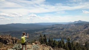
Either way you go, the final section is about a five-minute scramble up craggy boulders (tip: Cairns provide a route on the south side. Take your time and use caution). And the summit views? Cinematic. It’s an eye-max of the northern Sierra landscape, including mountain peaks like Mount Shasta and Mount Lassen, the Sierra Buttes Fire Lookout, as well as Bear Lakes, Silver Lake, and Round Lake to the south, and Gold Lake and the Sierra Valley to the east. There’s a scroll you can sign, and you’ll see remnants of a former fire lookout.

LISTEN TO THE PODCAST: In the episode "Secret Sierra" Weekend Sherpa co-founders discuss their trip to the summit of Mt. Elwell and exploring the Lakes Basin.

CAMPING TIP: There's great lakeside camping nearby in the Lakes Basin. Goose Lake Campground is a nice one with only 14 sites. There's also Gold Lake, Snag Lake, Haven Lake, and others.

For the shorter out-and-back option, start at the trailhead at the end of the Lakes Basin Campground. You’ll see two trailheads (Bear Lakes and Long Lake). Start on the Long Lake Trailhead. Hike up about 0.75 mile and turn right following the sign for the Long Lake Connector. This takes you to the Long Lake Trail, where you turn left and hike up to Mount Elwell following the signs. Return the way you came.

For the longer round-trip option: Start at the Smith Lake Trail near Gray Eagle Lodge. Hike up the Smith Lake Trail. Go left at the intersection with Smith Creek Trail. A short distance later bear left on Mount Elwell Trail. The trail ascends 3 miles to Mount Elwell. Descend on the Long Lake Trail, which takes you back to where you parked.

Trending Stories NorCal

View all Stories
  1. Perles Beach Angel Island San Francisco Bay

    Secret Beach

    A hidden beach and a killer view? Those are hard to come by, but that’s exactly what you’ll get at Perles Beach on Angel Island. Bike or hike to this beautiful pocket cove.

    View
  2. Cinematic Sonoma

    Longer days. Golden light. Wildflowers in bloom. It’s the perfect moment to plan your spring escape to Sonoma for the Sonoma International Film Festival, March 25–29. No fuss. No sprawl. Just films, friends, fresh air, and that unmistakable Sonoma glow.

    View
  3. Hike Pescadero Marsh Natural Preserve

    Mellow in the Marsh

    Beach, birds, ice plant popping purple flowers: That’s a hiking slam dunk! Hike about 2 miles at Pescadero Marsh Natural Preserve using their easy to navigate (well-signed) Sequoia Audubon Trail.

    View
  4. A man is looking through his binoculars at sunrise at the Bayland Nature Preserve in Palo Alto

    Baylands Bird & Art Loop

    Combine an outdoor art walk and wildlife sightings at the Baylands Nature Preserve in Palo Alto. This 5-mile loop through Byxbee Park and the Emily Renzel Wetlands features striking installations by artists Peter Richards and Michael Oppenheimer—where the landscape itself becomes part of the canvas.

    View

Trending Stories SoCal

View all Stories
  1. Tree Town

    Home to an estimated 21,000 trees and 100 acres of parkland, South Pasadena has earned its nickname: the City of Trees. This 2.5-mile neighborhood walk lets you experience its leafy canopy up close, winding through charming streets and three of the city’s beloved parks.

    View
  2. A Better Way to Baldwin

    The Baldwin Hills Scenic Overlook in Culver City is one of West L.A.’s most popular hiking spots, but most visitors miss the bigger picture. This 3.5-mile out-and-back along a section of the Park to Playa Trail offers a fuller experience of this gorgeous nature park with sweeping urban views and a few artistic surprises along the way.

    View
  3. Sponsored

    Warm Up to Winter in Reno Tahoe

    2026 is just getting started, but there’s one place already rising to the top as the best for adventure and relaxation: Reno Tahoe. The awe—and ahhhs—begin as soon as you arrive. G

    View
  4. A woman standing at the pond's edge at Ernest B Debs Regional Park in Los Angeles. Trees are making reflections on the pond.

    Urban Oasis Loop

    Home to the city’s Audubon Center, Ernest E. Debs' 282-acre park features a robust network of hiking trails and surprising wildlife diversity. More than 140 bird species have been spotted here. Birdwatcher or not, this 2.5-mile route makes for a gorgeous outing.

    View