Umpqua Waterfalls.mp4

Take the Plunge

Hike to Waterfalls Along the Southern Oregon Highway of Waterfalls

Two women looking up at Watson Falls, Southwest Oregon's highest waterfall

How can you take a road trip through Southern Oregon and not hit the Highway of Waterfalls? This stretch of Highway 138 east of Roseburg along the Umqua River is a watery marvel that’s terrific year-round. Winter sees fewer people, making it an ideal time to visit. While some waterfall hikes in the area are temporarily closed, you’re still going to find plenty of adventures to mesmerizing falls.

Watson Falls on the Highway of Waterfalls in Southern Oregon

That includes Southwest Oregon’s highest waterfall, Watson Falls. Go early in the morning for a good chance of having this 293-foot oasis all to yourself, at least for a little bit. It’s a forested and relatively easy 1-mile loop hike that’s lush with ferns under a canopy of Douglas fir and western hemlocks. You’ll cross a wooden bridge with an outstanding vantage of Watson Falls, but you can also continue up a spur trail to a viewpoint closer to the misty action. More waterfalls?! Of course! This is the Highway of Waterfalls, after all.

Check Out Southern Oregon's Highway of Waterfalls

Hiker going down stairs to a viewing platform overlooking Toketee Falls on the Highway of Waterfalls in Southern Oregon

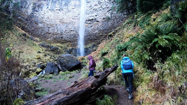
Toketee Falls is a thunderous tumbler. The name Toketee is a Chinook word for “pretty,” and that’s almost too modest. Toketee is a two-tiered stunner. The first 40-foot cascade plunges into a hidden pool and then the falls suddenly drop another 80 feet as the North Umpqua River squeezes through a notch in the balsatic rock. Hike 0.4 mile (one-way) beneath old-growth Douglas fir, big-leaf maples, and western red cedars to reach the viewing platform. Other waterfalls to check out include Clearwater and Lemolo.

Toketee Falls on the Highway of Waterfalls in Southern Oregon

Stay: Umpqua’s Last Resort kinda sounds like what it is … a last resort lodging option before you embark on the Highway of Waterfalls. But this is not a bad thing because Last Resort is an eclectic combination of cozy cabins, glamping tents, and RVs, including two amazing retro RVs that are well worth trying to snag. This Last Resort should be first on your priority planning.

Umpqua's Last Resort Retro red and white RV.

lThe Highway of Waterfalls is also known as the Rogue Umpqua Scenic Byway, or Highway 138, east of Roseburg.

Discover Oregon's 7 Distinct Regions and Get More Trip Ideas

Trending Stories NorCal

View all Stories
  1. Bear Hug

    This 5.5-mile loop through Coyote Lake-Harvey Bear Ranch County Park explores one of the newest segments of the acclaimed Bay Area Ridge Trail, one redolent with trees ranging from madrone and manzanita to buckeye and blue elderberry (with a bubbly post-hike bonus).

    View
  2. Field of Light at Sensorio in Paso Robles

    Light This Way

    Hidden in the bucolic hills of Paso Robles lies one of the greatest light shows on earth. The lighted art exhibition, Sensorio, is as if the rainbow magic of the aurora borealis was plucked from the sky and planted in the fields.

    View
  3. Bikers and walkers on the Bay Area Ridge Trail with the Golden Gate Bridge behind them

    National Park City Walk

    See San Francisco the way locals do by hiking the Presidio, a national park right in the city! Wooded trails, secluded beaches, and epic views of the Golden Gate Bridge feature on this 5.5-mile out-and-back on the Bay Area Ridge Trail. It’s a lovely slice of the City by the Bay.

    View
  4. Bucks Up!

    Come on in, the water is beautiful. Whether you like swimming, kayaking, stand-up paddling, or heading out on a bigger boat, Bucks Lake is a high mountain haven that’s easy to access, blissfully uncrowded, and surrounded by sandy beaches, picnic areas, pines, and aspens.

    View

Trending Stories SoCal

View all Stories
  1. Sponsored

    Tram to Cool Treks

    Elevate your fun, getting whisked from palm trees to alpine wilderness on the world’s largest rotating tramcar. The Palm Springs Aerial Tramway transports you up and away on a 2.5-mile scenic route from the desert floor to the refreshing wilderness of Mount San Jacinto State Park.

    View
  2. Coming Up Roses

    Looking to spice up your hiking life? Give your partner a rose—Mount Rose! The 10-mile out-and-back peak hike goes up to one of the grandest views in all of Lake Tahoe. Get ready f

    View
  3. A group of people clamored around the summit marker at Mission Peak in the Bay Area

    Your Mission Is Less Crowded

    Mission Peak is one of the Bay Area’s most popular mountains, with many hikers climbing every weekend. Skip the crowds with this 6-mile loop up the less-traveled southern route.

    View
  4. Vista Hermosa Park in Echo Park Los Angeles

    Vista Hermosa, Echo That!

    Tucked in Echo Park, the little-known gem of Vista Hermosa Natural Park feels worlds away thanks to its serene beauty and thoughtful design. At 11.5 acres there’s still plenty to explore. And it's got a premier view of the iconic Los Angeles skyline.

    View